After a long preparation, the so-called AMC (Accepted Means of Compliance) amendment containing SORA 2.5 was published on the website of the European Aviation Safety Agency (EASA) on September 29. The renewed AMC describes the new methodology for mandatory risk analysis in the special operation category, which must be applied uniformly throughout the European Union. Applications for new operating permits must now be submitted in accordance with SORA 2.5, and operating permits already in force (including the documentation of LUC holders) must be brought into line with SORA 2.5 within two years, according to the EASA decision. In our article series, we will review the most significant changes that impact the methodology.
In one of our previous articles we wrote about the changes implemented with the introduction of SORA 2.5, the table for determining the intrinsic ground risk class was presented, and in another article, we described the new system of ground risk mitigation measures. The new methodology places greater emphasis on the determination of population density and the reliability of the database used by the operator to support the population density data. In addition, static and dynamic population density also play a role in the new methodology. This article will focus on static population density considerations.
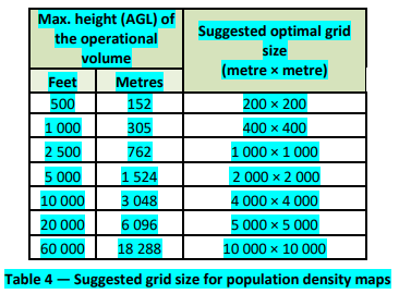
Basically, it will be up to the competent authorities to determine which databases and population density maps they accept. However, the operator may also propose a different database or map. According to S.4.2.4 of SORA 2.5, “determining the population density to calculate the iGRC in Step #2 should be done using maps with an appropriate grid size based on the intended operation. Competent authorities should designate specific maps to be used for determining population densities.” The appropriate grid sizes are listed in this table below.
If such a map showing static population density is not available, then it is still possible to use the so-called qualitative ground risk classification (i.e. determination is based on general characteristics) similar to the one used until now under SORA 2.0. For instance, we can speak of lightly populated areas in the case of smaller agricultural settlements and farms, where the average property size is at least four acres with presumed population density of >50 ppl/sqm. If the average lot size is not greater than 1 acre, that area is considered as sparsely populated area with presumed >500ppl/sqm. population density, even if there is no precise data on the exact population density in any of these two cases.